
Southern Region Fire Adaptation: assessing wildfire risks and opportunities for risk management
PARTNERS: USDA Forest Service Southern Region, Fire & Aviation Management (FAM); Southern Group of State Foresters; Southeast Cohesive Wildland Fire Management Strategy
SUMMARY
The Southern Region Fire Adaptation project is undertaken by Threat Center scientists in collaboration with USDA Forest Service Region 8. The intent of the risk assessment and firescapes mapping components of this project is to support strategic planning by estimating the potential for harm to people and to ecosystem services posed by wildfire, as well as the potential for appropriate management decisions to reduce risk. To help ensure management relevance of the products, the analysis was co-developed with a regional team of expert partners, and model development was in part expert-driven.
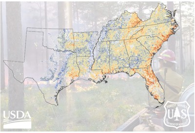
The wildfire risk assessment resulted in maps of relative risk across forested landscapes in the Southern United States. Spatial data products are provided to users (links below). Image by USDA Forest Service.
Risk components quantified in this product include (1) risk from direct exposure of people and structures to fire; (2) risk of smoke emissions from forests exposing nearby populations at (EPA-defined) harmful concentrations; (3) risk to surface water quality and quantity in watersheds that are important for downstream drinking water outtakes; (4) risk to forest carbon stocks from loss during intense fire; and (5) a combined risk with importance weights assigned to each of these four components. The analysis also incorporates a socio-economic vulnerability measure in estimating overall vulnerabilities. Socioeconomic conditions such as wealth and poverty, housing type, mobility, and household composition can determine how prepared a community is for fire, and the capacity for recovery in the aftermath of fire.
All lands in the Southern Region of the US with at least 25% forest cover are included in the analysis. A Bayesian network model was developed to integrate relevant spatial data and provide probabilistic estimates of wildfire risk, and to evaluate the role that fuel reductions can play in managing risk at the landscape level.
The model uses a scenario-based approach to evaluate the value of fuel reduction investments for reducing risk. The model implements two alternative scenarios— (1) business as usual, for which the estimated fuel load is not altered, and (2) investment in an enhanced fuel reduction program, wherein fuels are reduced by approximately half. The 'relative utility' of fuel reductions then estimates the degree to which outcomes under the fuel reduction scenario are more desirable than the alternative. This process places greater value on risk reductions in high-risk landscapes, where the need is most urgent. The result is a regional map of high-value opportunities for managing forests to reduce risk efficiently.
Mapping Firescapes
Firescapes are landscape types defined by unique social and ecological characteristics which are important for understanding how fire and associated risks operate as a human-environment system. The motivation for mapping firescapes is to characterize landscapes in a way that helps inform locally appropriate fire management strategies such as wildfire risk management through the use of prescribed fire and community wildfire preparedness investments. Firescapes provide a broad-scale context for considering such strategies in different landscape types and socioecological settings.
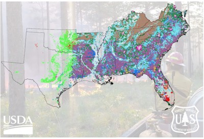
Firescapes were mapped across forested landscapes in the Southern United States, and spatial data products are provided to users. Nine distinctive firescapes, each shown here with a different color, were identified through analysis of 73 spatial variables. Image by USDA Forest Service.
We used a two-tiered approach to to delineate forest-dominated firescapes across the region, assessing current landscape characteristics with respect to fire, communities, ecosystem services, forest management opportunities, conservation values, and other attributes. First, we synthesized diverse spatial data sets, which are catalogued in the article referenced below. Starting with 73 spatial variables, we used factor analysis, a data reduction technique, to produce eight new variables (factors) that explain much of the variability in the original dataset. These factors have intuitive interpretations with respect to fire dynamics, fire history, forest characteristics, climate, conservation values, social and ecological vulnerabilities, and landscape change. We then classified landscapes using the factors in a cluster analysis. Cluster analysis is a statistical approach to group observations (in this case, the hexagonal landscape units) with similar properties into classes-- which we term firescapes.
EFETAC'S ROLE: This project is supported by Eastern Threat Center research and science delivery.
STATUS: Initiated 2022; Ongoing.
PRODUCTS:
Publicly available spatial data products: GIS-ready risk assessment data layers for the Southern US, and Firescape data layers for the Southern US, hosted in AGOL by the USDA Forest Service Southern Region.
PUBLICATIONS:
Nepal, S., LY Pomara, NP Gould, and DC Lee (2023). Wildfire Risk Assessment for Strategic Forest Management in the Southern United States: A Bayesian Network Modeling Approach. Land 12(12): 2172.
Gould, N.P., LY Pomara, S Nepal, SL Goodrick, and DC Lee (2023). Mapping Firescapes for Wild and Prescribed Fire Management: A Landscape Classification Approach. Land 12(12): 2180.
CONTACT:
Lars Pomara, Eastern Threat Center Ecologist, lazarus.y.pomara@usda.gov or (512) 501-0260
Updated March 2024
