
Assessing forest tree risk of extinction and genetic degradation from climate change
SUMMARY: Climate change poses a severe threat to the viability of several forest tree species, which may be forced either to adapt to new conditions or to shift their ranges to more favorable environments; species with limited geographic ranges are at highest risk. To help natural resource managers, land-use planners, and conservation organizations target tree species for monitoring, conservation, and management activities, Eastern Threat Center scientists used spatial models of future environmental conditions to predict and map the location and quality of habitat for several hundred North American forest tree species. Known as the Forecasts of Climate-Associated Shifts in Tree Species (ForeCASTS) project, scientists also determined where each species, within its current range, is most susceptible to extinction as a result of climate change.
Scientists mapped global range shifts for 337 tree species under different climate change models and emissions scenarios for the years 2050 and 2100. Most species’ predicted suitable ranges are predicted to decline in suitable habitat area by 2050 under the Hadley B1 global circulation model/emissions scenario combination, with eastern species expected to experience less range stability than western species (Potter and Hargrove 2013). ForeCASTS also includes maps of Minimum Required Movement that detail the closest geographic locations, or “lifeboat” areas, offering future suitable habitat conditions and show the likelihood of local extinction following climate change.
EFETAC’S ROLE: The project was led in cooperation with Eastern Threat Center ecologist Bill Hargrove, and was supported by Eastern Threat Center funding.
STATUS: Completed
PROGRESS: Researchers prepared the Forest Inventory and Analysis training data for the production of maps predicting the location and quality of current and future habitat of 337 North American tree species using Eastern Threat Center ecologist Bill Hargrove’s Multivariate Spatio-Temporal Clustering (MSTC) technique. These datasets were then used to generate, for each species:
• 18 habitat suitability maps (currently suitable habitat for each species, and future suitable habitat under two global change models and under two climate change scenarios in 2050 and 2100, each separately for the conterminous United States and for the globe)
• five maps that identify areas of potential risk as a result of change over time in the location of suitable habitat, including Minimum Required Movement Distance (MRM) and Optimal Required Movement Distance (ORM), and
• a set of metrics of species-level projected climate change pressure, including percent change in suitable area, range stability over time, range shift pressure to any acceptable future habitat, range shift pressure to identical future habitat, realized current niche occupancy, and proportion of no identical future habitat
Researchers generated these sets of 23 maps for each species twice, once with elevation as a spatial environmental characteristic and once without, to compare the results between the two. (See examples below.)
The collaborators also designed a website for the presentation of these results. This site includes a description of the overall project, background information on how the maps are generated, and an explanation of how to interpret the maps. Associated geographic information system (GIS) files are available for download at the site. To fill in these gaps for the future generation of MSTC and MRM maps, researchers searched for additional species occurrences from the Global Biodiversity Information Facility data portal (http://data.gbif.org).
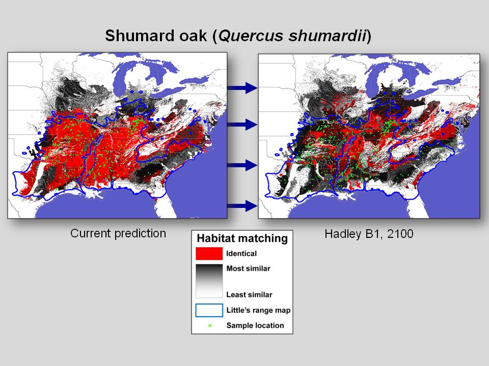 Left: Multivariate Spatio-Temporal Clustering results for Shumard oak (Quercus shumardii), depicting currently suitable habitat (left) and habitat predicted to be suitable in 2100 under the Hadley B1 scenario. Click image to enlarge.
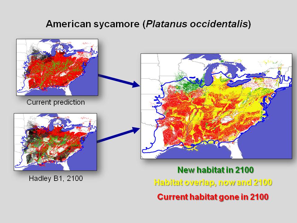 Right: Minimum Required Movement results for American sycamore (Platanus occidentalis), depicting areas of habitat overlap and non-overlap (right) between currently suitable habitat (top left) and habitat predicted to be suitable in 2100 under the Hadley B1 scenario (bottom left). Click image to enlarge.
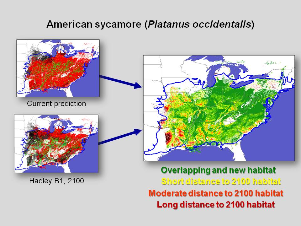 Left: Minimum Required Movement results for American sycamore (Platanus occidentalis), depicting the distance (right) between between currently suitable habitat (top left) and habitat predicted to be suitable in 2100 under the Hadley B1 scenario (bottom left). Click image to enlarge.
Potter, K.M., W.W. Hargrove, and F.H. Koch. In press. Assessing forest tree risk of extinction and genetic degradation from climate change (SO-EM-09-01). Chapter 17 in K.M. Potter and B.L. Conkling, eds., Forest Health Monitoring: National Status, Trends and Analysis, 2014. General Technical Report SRS-xxx. Asheville, North Carolina: U.S. Department of Agriculture, Forest Service, Southern Research Station.
Potter, K.M. and W.W. Hargrove. 2013. Quantitative metrics for assessing predicted climate change pressure on North American tree species. Mathematical and Computational Forestry and Natural Resources Sciences. 5(2):151-169. (PDF)
Potter, K.M. and W.W. Hargrove. 2012. Determining suitable locations for seed transfer under climate change: A global quantitative method. New Forests 43(5-6):581-599. (PDF)
Potter, K.M., W.W. Hargrove, and F.H. Koch. 2010. Predicting climate change extirpation risk for central and southern Appalachian forest tree species. Proceedings from the Conference on Ecology and Management of High-Elevation Forests of the Central and Southern Appalachian Mountains. J.S. Rentch and T.M. Schuler, eds. Snowshoe, West Virginia, May 14-15, 2009. General Technical Report NRS-P-64. Newtown Square, Pennsylvania: U.S. Department of Agriculture, Forest Service, Northern Research Station. pp. 179-189. (PDF)
This research has been described in a number of presentations.
LINKS:
Atlas of Climate Change Genetic Risk
Related articles from CompassLive:
"Which Tree Species are Most at Risk in a Changing Climate?"
CONTACT: Bill Hargrove, Eastern Threat Center Ecologist, william.w.hargrove@usda.gov or 828-257-4846
Updated June 2015
